Departure: Terni
Arrival: Arrone
Distance: 14.3 km
Ascent from Departure: + 313 m
Descent from Departure: – 209 m
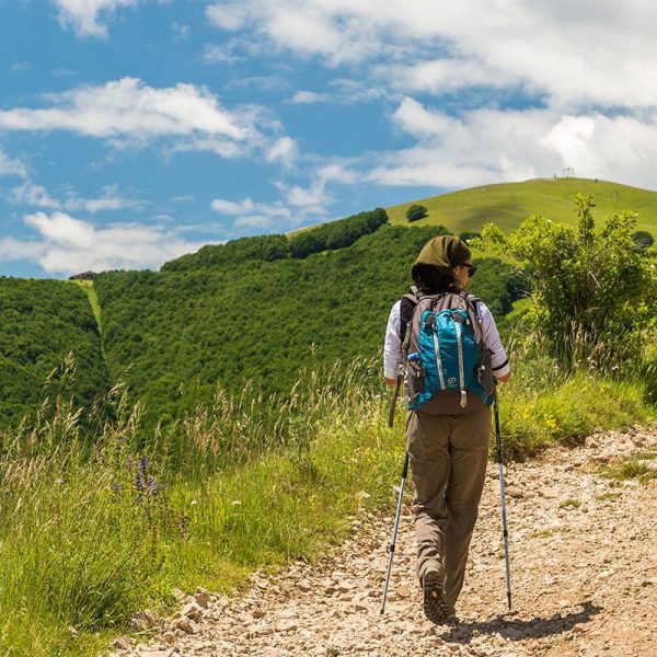
Difficulty: easy
Terrain: gravel & asphalt road
Length: 3.5 hours
Potable Water: yes (Terni, Papigno, Castel di Lago, Arrone)
Rest Stops: yes
Signage: yes (vertical and horizontal yellow & blue)
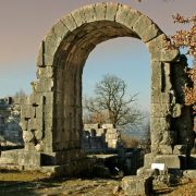
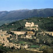
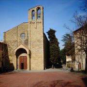
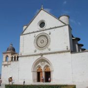
Leave from the central Piazza Europa, taking a right on Via Garibaldi. Cross the bridge over the Nera River, continuing along Via Vitalone. After the underpass (km 0.85), turn right down the stairs, then left on the sidewalk along the busy Via Vitalone. At the bus shelter, cross over to the left side of the street using the crosswalk; from here, continue straight, turning left on Strada Santa Maria Maddalena after 100 meters while keeping watch for passing vehicles. At the crossroads (km 1.5), continue on Strada Valle Stretta. Step by step you will distance yourself from the city center, nearing the vegetable garden-covered outskirts. Pass under the historic gate of a patrician villa–where there is a water fountain—continuing along Strada Valle Stretta. At the intersection, turn left onto Via della Sponga (km 2.4); you will shortly pass a water fountain. Continue along the asphalt road, turning right at the entrance to an art nouveau-style villa (km 3). Once you reach the busy SS79, turn left pass an old school (notice the curious separate entrances for boys and girls). Continue towards Papigno; at the crossroads marked by a shrine with a cross (km 3.7), turn left downhill. Follow the quieter asphalt road until reaching Papigno’s Piazza Giovanni di Giuli, where you can rest and stock up on food and water. Continue left, descending along Via Carlo Neri (km 4.5) without entering the center of town. After 100 meters, turn left down the stairs leading to the entrance to a former industrial building (now a film studio–Cinecittà Umbria Studios—made famous by Roberto Benigni, who made “Life is Beautiful” here). Pass the entrance to the building on the right and cross the bridge over the Nera River to reach the SR 209 – Valnerina. Turn right and walk along the shoulder of the road, paying close attention to vehicles passing at high speed. The road widens (km 5.9); at the vertical “Cascata delle Marmore” signage, turn right onto Via Ponte del Toro, crossing the bridge on the right. Continue to the left along a secondary road, reaching the Ponte del Toro (1st century B.C.) archaeological site after a steep climb. At the signage for a restaurant, leave the asphalt road where it curves to pick up the trail. At the intersection, turn left downhill to the wooden gate (km 6.4) to the Cascata delle Marmore park area. Passing the gate (it’s always closed), head toward the exit of the Cascata delle Marmore, enjoying the beautiful view over the falls. Continue towards the ticket office, passing through the shopping area on the left then turning right along a tractor track. After the bridge, turn left and follow the signage for “Campacci di Marmore”. At the trout farm, turn right following the red and white CAI signage. Begin to climb to where the trail meets up with the route marked with “Via di Francesco” signage to Arrone. The route continues level along the Valle del Fiume Nera, or Valnerina, at times skirting the river banks and at others running parallel to the river across cultivated fields. At the end of the unpaved road (km 7.8), continue along asphalt, passing an iron cross. Follow the signage for the Way, turning left at the intersection (km 8.32) and continuing along asphalt. Near the bridge–but before passing over it–turn right along the Nera River. At the crossroads (km 10.52), continue right towards the fortified hamlet of Castel di Lago. At the town, turn left at the intersection (km 10.73) where there is a hotel to the right. After passing the town streets (km 11.13), continue along an asphalt road from where you will see Arrone in the distance. On the right, you will see the arches of the Convento di San Francesco (km 11.7). After less than 1 kilometer and an easy climb, you will reach la collegiata di Santa Maria Assunta in the center of the village (km 13).


